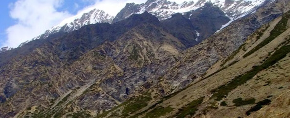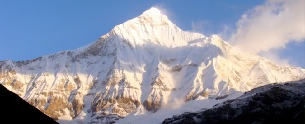


About Nanda Devi East base camp
Nanda Devi East A.B.C trek does not come in the purview of a simple trek. If adequate attention is not given to logistics it can be damning especially if you are planning to climb Longstaff col which is tantalizingly so close to the advanced base camp of Nanda Devi East. It is a tough trek ranging from easy parts in the beginning which slowly becomes tougher in the later stages- so adequate preparation is a must.
After a bone-grinding journey from Haldwani, you arrive at the sleepy hamlet of Munsiyar and take refuge in Pandey Lodge. Depending on your past interaction with Mr Pandey, the lodge owner, the cost of rooms will range between Rs 200 and 500. Other similarly priced lodges abound in that area which is very close to the market.
For costlier and plusher accommodations you may choose Zara Lodge,which is higher up. You can then look around for a muleteer who will be your companion with his pack horses or mules for the next four days to Martoli after which only porters can carry equipment. Shopping in Munsiyari for vegetables and potatoes is required as you can always lug provisions like fuel tanks of propane, lentils, wheat flour, rice, tea, sugar etc from Delhi or wherever your journey begins. Kerosene is not easily available in the hills so you need to procure it in advance.
While resting at Munsiyari you are also acclimatizing for the trek as it stands at 7513 ft (2290 metres). You will need to find a reliable Tempo Trax or Sumo SUV that will carry the team members, provisions and equipment to Dhapa, 10 km away, where the trek starts. The cost of an SUV is between Rs. 300 to 350 per vehicle and can accommodate about seven people with their equipment on top. The muleteer will arrive there directly from the nearby Madkotevillage and surrounding areas where most of the mule teams have their homes. Each mule, perparav (hill destinations which can be a 12 to 15 km stretch) can cost Rs. 400 to Rs. 500. Stiff bargaining is required as the muleteer will try to reduce the distance of a parav which automatically spells more money in his pocket.
Brief ITINERARY
Day-1
Munsiyari to Lilam
Day-2
Lilam to Bugdiyar
Day-3
Bugdiyar to Martoli Via Rilkot
Day-4
Rest day & exploration of Martoli
Day-5
Patta to Bittalgwar to Nandadevi east base camp (N.D.E – B.C) via Narspanpati herding ground
Day-6
Basecamp to Nandadevi East Advance Base Camp
Day-7
Nanda Devi East ABC to Naspanpati, 3 hour
DETAILED ITINERARY
Day 1 -Munsiyari to Lilam
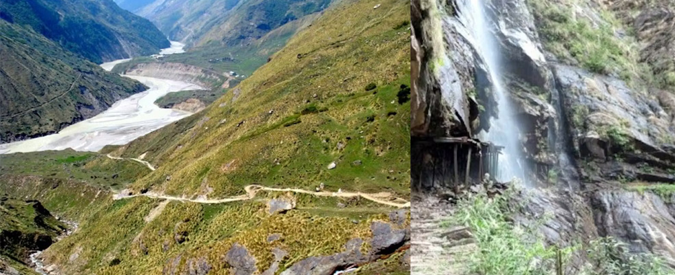
7513 ft (2290 metres) to 6069 ft (1850 metres), 14 km with 8 km of trekking from Dhapaonwards. Steep descent to Jimighat next to the Gori Ganga River. Then a steady three-hour walk upwards along the true right of the valley to Lilam. You board the waiting vehicles to Dhapa early in the morning after breakfast at a few tea houses which serve noodles and snacks. Here the mules are loaded and they come by a separate long route for pack animals. Team members walk down a pretty steep gradient which can be a knee-jarring 2 km descent to the bridge spanning the Gori Ganga at a place called Jimighat.
There is also the easier mule track which is 5 km long but to save time it is better to take the shorter route using one’s climbing poles for balance. Having avoided the stinging nettles that grow all along the descent you then scramble downwards to cross the bridge at Jimighat and proceed on a track that meanders upwards which you can easily complete in 2-3 hours, depending on your level of fitness and arrive at the first stop which is Lilam village at a height of 1850 meters or 6068 feet. The first view of this village is a few corrugated aluminum ITBP prefabs where you meet the guards manning the check post and sign in showing them the duly signed and stamped form from their superior officer in Munsiyari. Here you may unpack and cook a meal after laying down the tents but time can be saved by eating at tea-houses that are found all along the route till Martoli -where an unlimited hearty meal of radish and spinach curry with chapatties is priced at Rs. 70 and remains the same all along the route. Tea costs Rs. 10 and if anyone wants a change the tea-house owner can whip up a meal of Maggi noodles and eggs too. Stay at the tea-house for the night is free as one has already partaken of a meal there and even if they ask for money it will be a nominal Rs 10 to Rs 20 per person. You can lay your mat and sleeping bag on straw mats laid out on wooden planks that constitute a bed. This way time and energy spent on unpacking and repacking are saved till you reach Martoli.
Day 2 - Lilam to Bugdiyar
6069 ft (1850 metres) to 8200 ft (2500 meters), 15 km trek, 6 hours. The trail climbs up a ridge through a gorge passing through mixed forests of conifer and bamboo and crossing waterfalls and snow bridges to reach Bugdiyar.
While trekking from Lilam to Rilgari, called Railgari by locals, you pass through a natural tunnel formed from two huge rocks. Departure from Lilam is in the wee hours of the morning to avoid the sweltering heat of the day, as Lilam is still at lower heights. The original route followed the river but due to massive landslides, a new route has been constructed up in the Lilam ridge. This trail moves along the right of the valley above the raging Gori Ganga and you soon enter a gorge where the Gori Ganga thunders due to a series of rapids. 3-4 km after the gorge is a bifurcation where one road leads up into the ridge which you must avoid taking. You need to take the path going down to the river made of boulders held by metal wires hugging the cliff with the river raging alongside. You then come to Rirgari which is a few dhabas beneath an impressive overhang of a cliff face.
A few kilometres further down the trail is an area called Garam Pani where hot springs are found. You can go down to the river and soak your tired limbs beside the river where sulphur springs mix with the cold water. Now comes a series of switchbacks through conifer and oak forests through which the path weaves for 4 to 5 km till it reaches the settlement of Bugdiyarwhich has the customary ITBP hut where you sign in. Next to it is a PWD hut where, if lucky, you can check in as it is bang next to the river. Another option is the tea-house just above the PWD hut that offers meals and hot sweet sticky tea. Bugdiyar at 8200 ft (2,500 meters) is a total of 14 to 15 km from Lilam and takes 5 to 6 hours depending on diversions and rest time.
Day 3 - Bugdiyar to Martoli Via Rilkot
8200 ft (2500 meters) to 11250 ft (3430 meters) via Rilkot, 20 km, 8 to 9 hours. The trail is alongside the Gori Ganga river through narrow gorges and then a steady climb up to Rilkot. After Rilkot a steep 3 km climb and then a steady 4 km climb to the plateau of Martoli. You now follow the Gori Ganga and reach a Hindu temple beneath a rock 3 km from Bugdiyar also called Bodgwar. The gorge becomes narrower and you come across many waterfalls and a series of snow bridges which the locals say exist throughout the year. After 4 km the gorge widens and enters a meadow and two trails bifurcate from here to form a higher trail for mules and the lower one for trekkers. You then reach a tea-house run by a jolly Laspa lady and her husband. After a round of sticky sweet tea and biscuits, you proceed to a village above called Laspa from where you enter a pass called the Laspadhura or Laspa pass. This pass leads to the East Shalang glacier that emerges near Nandakot and is an alternative route to Nanda Devi East base camp which we were going to attempt via the Lwanlgad from Martoli. You then camp upon the meadows of Rilkot with its corrugated iron-roofed ITBP huts and a tea house with horses and sheep feeding in the high grounds lining this village at 3,100 meters or 10,168 feet.
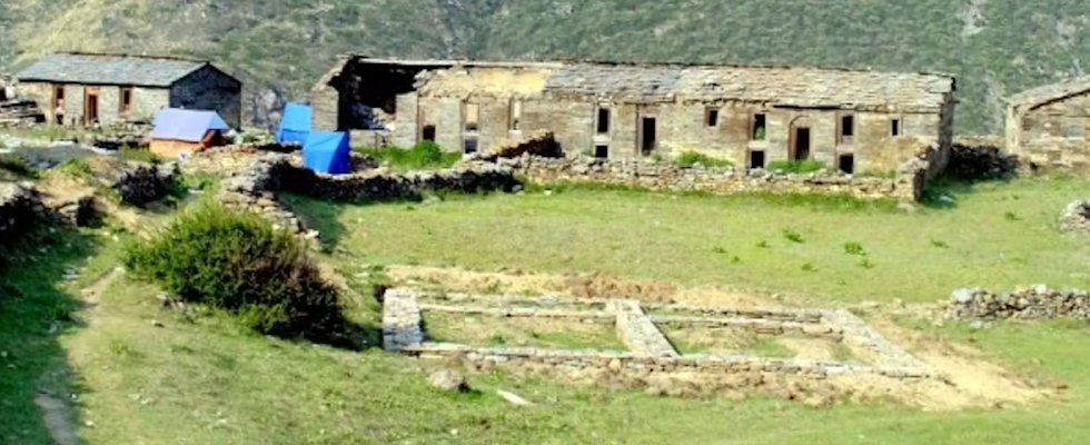
After a hearty lunch at the tea house down with tea you then proceed on a real steep climb of 6 to 7 km over flat stones forming almost a staircase in the beginning to a flatter surface towards the end. Note the bifurcation towards the end as you can carry on towards the Milam glacier route instead of climbing to the delightful grassy plateau of Martoli guarded by its presiding deity the peak of Martoli. From this area where the bifurcation takes place, you can spot the villages of Tola or Toling and Sundu on the opposite side, which is the true left of the valley across the Gori Ganga, from where a path meanders to the Brij Ganga Pass at 4,700 meters crossing which one comes to Ralam village. Martoli has a delightful place called Munna’s lodge which is in the middle of the village. Another guest-house called Hotel Nandadevi run by an ex-policeman, Shri Mahender Singh Martolia, has the only satellite phone in town, which incidentally works only on a clear day as the only power source is his solar battery and the dish antenna needs clear skies. Calls at Rs. 3 per minute is pretty reasonable considering no mobile phone works after Munsiyari.
Day 4 - Rest day & exploration of Martoli
Rest and acclimatizing at Martoli plus unpacking and distribution of supplies for base camp and advance base camp. Exploration day at Martoli Village and surrounding areas. Resting at this lovely deserted village at a height of 3,430 metres or 11,250 feet is necessary before the last stage of the trek. From here you proceed to a height of 14,000 feet that increases to 15,500 feet near the advance base camp of Nanda Devi East. Unpacking the team’s food supplies and distribution for the trek ahead is a daunting task as you have to take care that the right provisions are carried for the final push up Longstaff col. Chocolates, nuts, dried fruits and proteins plus carbohydrates in the form of dried potato powder and dried vegetables and soups that can provide energy at high altitudes are put in separate bags for carriage. Then comes the task of hiring porters from Tola or Burfu as most of the able-bodied men of Martoli go looking for Kheera Ghaas or Yarsa Gombu (a fungus that grows on a caterpillar in the high plateaus, which is then exported to China for its medicinal qualities and costs anywhere between 3-5 lakhs per kilo).
From Martoli mules cannot go further than two to three km as the trail is broken and is more of a mud trail that cannot support the weight of pack horses or mules. The only animals to be seen after this are sheep and long-haired goats with salt bags on their back grazing in the meadows of the high sierra and breaking the trail of mud and stone even further.
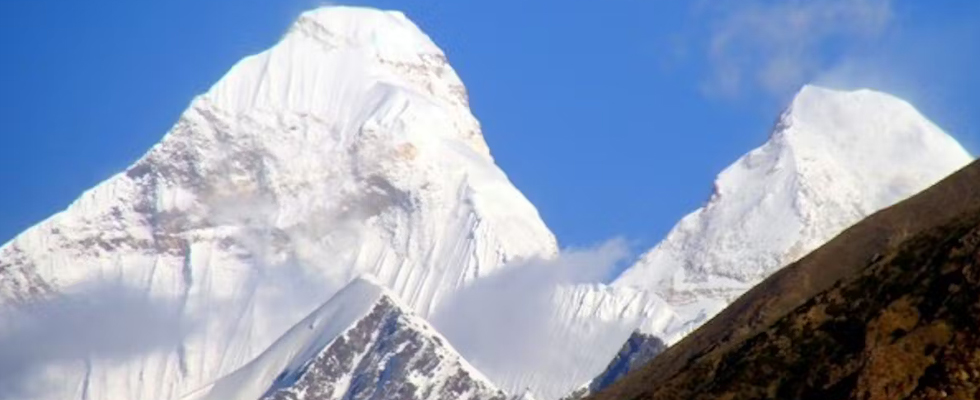
The religious members of the team may visit the Nanda Devi temple in the shadow of the Martoli peak to pray for a safe journey while some may wish to get up early the next morning for a photo session from that vantage point with clear views of the two peaks of Nanda Devi and Nanda Lapak. If lucky, you can also get views of Trisuli far away in the Milam Glacier area.
After the strenuous activity of hopping past birch and rhododendron and taking care not to slip on the soft clumps of elephant grass, we were glad to get down to the river bed. The trail now goes down to the river bed where there is a lot of boulder hopping. After this, you need to cross a few slippery snow bridges keeping to the true right of the valley. While negotiating the slippery stones near waterfalls you also need to figure out how to hold onto stones in the collapsing mud walls and move ahead.
The technique is to softly clasp a stone with one hand and kick a ledge in the soft mud wall and swing the other leg in a concerted move to get a foothold while looking for another stone to hold onto. You now come upon the campsite of Patta which has a ready source of water from a stream flowing nearby. The task of having to set up a tent and cook is the first priority as there are no more ready-made meals or shelters. Sleep is greatly welcome after this exhausting day.
Day 5 - Patta to Bittalgwar to Nandadevi east base camp (N.D.E – B.C) via Narspanpati herding ground
11975 ft (3650 Meters) to 14107 ft (4300 Meters), total 14 km: Patta to Narspanpati 9 km and Narspanpati to Bittalgwaar 5 km. 4-5 hours. This is the toughest day as there were many ice bridges and boulders to cross while moving along the broken wall of mud and stones on the right of the valley to descend to the river. A few obelisk-like boulders placed strategically in the elephant grass indicate the path to take.
11975 ft (3650 Meters) to 14107 ft (4300 Meters), total 14 km: Patta to Narspanpati 9 km and Narspanpati to Bittalgwaar 5 km. 4-5 hours. This is the toughest day as there were many ice bridges and boulders to cross while moving along the broken wall of mud and stones on the right of the valley to descend to the river. A few obelisk-like boulders placed strategically in the elephant grass indicate the path to take.
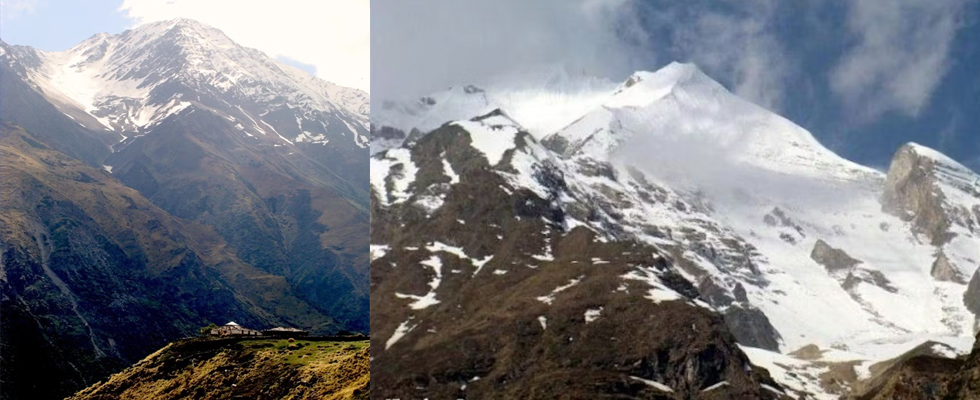
A final snow bridge crossing brings you to the wide meadow of Naspanpati or Narspanpatti. Here the Indian army helicopters land on reconnaissance flights at an altitude of 12630 ft (3850 metres). Sheep and long-haired goats can be seen grazing in the shade of the mighty Kuchela with distant views of the queen of peaks Changuch and Nandakhat.
After about three hours you cross the river on ice to reach Naspanpati (at an altitude of 3850 meters). This is a beautiful wide meadow with a lot of flowers. You also come across a cave carved out of a big boulder that can accommodate about 4 people. Opposite these green grassy slopes, you can see the yellow and green tents of the Indian Mountaineering Foundation team led by Wallambok and Dhruv Joshi as informed at the ITBP head office in Munsiyari.
The trail now runs along the true left of the valley and you climb 4 km of grassy knolls alternating with the same gravel-mud-rock combine of collapsing walls and landslide zones. You then descend and cross a stream to arrive at the stone shepherd’s hut of Bittalgwaar. While walking on this high wall to arrive at this spot you can see, on the opposite side, the scree wall that marks the ShalangGaad which you cross over to from Laspa village to arrive at Bittalgwaar.
It is evening by now so you set up camp and crash early after dinner to get up early and photograph the plethora of peaks ranging from Nandakot to Nandalapak, Nanda Devi East and Kuchela.
Day 6 - Basecamp to Nandadevi East Advance Base Camp
14107 ft (4300 Meters ) to 15750 ft (4800 Meters), 4 Km, 3-4 hours. Involves crossing a glacial stream and then walking over the remnants of a glacier and climbing to the advanced base camp which lies in the shadow of Nanda Devi East. The seventh day is a leisurely walk with boulder hopping and moraine crossing. You cross a glacial stream and then walk over the remnants of a glacier and climb to the advanced base camp which lies in the shadow of Nanda Devi East.
After traversing the boulder terrain you get back to the hills onto some very narrow, slippery trails with steep drop-offs. Hiking poles come in use in landslide areas with narrow slippery trails. The terrain around Nanda Devi East base is said to be a place of lovely meadows.
You reach the basin after 6 hours of hiking. The meadows here were bare with steep piles of scree, boulders and mixed rock.
You need to locate a 20-foot-high boulder at the bottom of the basin from where you can ford the stream. Stay on your side of the stream and head up over the lip of the basin, closer to the snow slopes above. After another half an hour’s stone stepping you find a spectacular campsite carpeted with pink flowers situated between a steep snow slope on the left and a steep brown moraine on the right.
There's a cave-type shelter suitable for the porters and for cooking. The main wall of Longstaff’s Col lies directly ahead of the campsite.
At ABC the lack of a water source poses a problem. The porters can be sent to get water from the stream at the bottom of the basin.As soon as the sun sets it becomes very cold but not dark. The moon and other celestial bodies cause the mountains to glow with enough illumination to take photographs.
Day7 -Nanda Devi East ABC to Naspanpati, 3 hour
On day 7 the team retreats to the lower grounds of Naspanpati by crossing the terminal moraine which is exposed boulders where once lay a bed of ice. While hopping down from boulder to boulder you hear the booming of a hollow shell with water running far down below illustrating the fragility of that place. You need to slowly but painfully go down to the dry river bed below where rivulets course their way to form the final raging stream on the right of the valley. While going down there were furtive glances to look back at the amphitheater where Nanda Devi East had entertained us for the past few days with her theatrics of avalanches, brilliant crystalline snow showers revealing her beautiful flanks as the clouds lifted.
The mercurial weather changing due to the mountain's own eco-system affected the whole area around and the clouds closing in gave a dull gray outlook all around. Now came the graveyard where many souls lay in their quest to climb the two peaks and other outliers of Nandakot like Kuchela peak. The gravestones were a grim reminder of the fragility of human life but also outlined the adventurous spirit of men who persevered to overcome all odds.
Crossing the cold Himalayan stream over to the left of the valley you climb up the scree slopes again and into the juniper bushes. The team came down to the grazing grounds of Naspanpati within a span of three hours to spot many sheep grazing -which was a welcome sign of human habitation.The shepherd dogs welcomed us again with wagging tails as they had become familiar with us and were happy to get some treats. We were followed by friendly sheep that would try to nibble from our hands any handouts that we would dig out of our sacks. Again sleep took over after tea and we had a hearty dinner served by the herders beside a roaring bonfire.
Cost Terms
COSTS INCLUDES
High-quality trekking gears (Tents, Sleeping Bags, Gaiters, Crampons).
Experienced Staff (Guides, Cooking Staff, Helpers, Porters).
Delicious, Hygienic & Nutritious Meals on scheduled time (Morning Tea, Breakfast, Lunch, Evening Snacks & Dinner).
Warm water for drinking only in the morning and evening. Trekkers can fill up their thermos-flask and bottles accordingly.
All forest permits and camping charges.
COSTS EXCLUDES
Food items purchased by individuals at local canteens on the trek or during the drive.
Any early return travel costs or accommodation except for the days as per the itinerary.
Any expenses for medical treatment of injury or accident before, during or after the trek.
Heater, geyser, firewood/bonfire are not included or covered in the package.
Hot water for bathing/washing or any other purpose except drinking*
All the cutlery (mugs, spoons, plate,lunch box etc)
To and Fro traveling charges.
CANCELLATION POLICY
In case you wish to cancel your trek please email us at sonunix7077@gmail.com
Cancellation charges are based on the total trek fee, irrespective of the amount paid either full or partial.
The cancellation policy is based on the original booking time and original start date of the trek.
- Cancel before 30 days of trek start date and get full refund after deduction of 2.5% payment processing fee.
- Cancel before 15 days of trek start date and get refund after deduction of 20% of total trek fee.
- Cancel before 10 days of trek start date and get refund after deduction of 40% of total trek fee.
- Cancel before 5 days of trek start date and get refund after deduction of 60% of total trek fee.
- Trek fee is non-refundable if you cancel within 4 days before trek start date.
Trek cancellation due to weather:
- In case of an incomplete trek due to weather conditions, one can opt for the same trek again throughout their lifetime on all our fixed departure for the same trek.
- This attempt only covers the trek fee and will not include any rentals or the transportation amount paid earlier.
- This is non-transferable.
NOTE:-
1)- Change of trek batch is dependent on the availability of seats in the batch.2)- In case of transferring a trek to a friend, he/ she should satisfy all the mandatory requirements put forward by Himveer Tour & Trek .
3)- Himveer Tour & Trek holds the right to change/cancel the policies, without prior notice.
Cancellation is processed only by email intimation. Please email any cancellation requests to :- sonunix7077@gmail.com or call us @ +91-7500124928 Itineraries are based on information available at the time of planning and are subject to change. "Himveer Tour & Trek" reserves the right to change expedition dates, people or itineraries as conditions warrant. If a trip must be delayed or the itinerary changed due to bad weather, road conditions, transportation delays, government intervention, airline schedules, sickness, or other contingency for which Himveer Tour & Trek or its agents cannot make provision, the cost of delays and/or other changes are the responsibility of the participant. Himveer Tour & Trek reserves the right to decline, or accept, any individual as a trip member for any reason whatsoever.
Please Note
*Written cancellation will be accepted on working days (only). Any cancellation sent on a Sunday or any National Holiday(s), will be considered on the next official working day.
*In the event of any cancellation(s) after trip commencement, there will be no refunds and any costs incurred due to this cancellation will be borne by you.
Irrespective of when a trip is booked, the above condition will hold true.
Himveer Tour & Trek GUIDELINES
DO’S AND DON’TS ON A TREK
1.Alcohols or any other intoxicating products "STRICTLY PROHIBHITED" during the trek.
2.Always pay heed to the trek guides or instructors.
3.Try not to leave the group under any circumstances.
4.Avoid trekking during the nights as it is extremely dangerous.
5.Avoid using earphones as that might hinder your hearing.
6.Do not participate or encourage littering of the places in any form.
7.While visiting the local villages and tourist sites, obey the local guidelines and instructions.
8.Do not harm or interrupt the local sentiments of the places.
IMPORTANT:
Your safety is of paramount concern while travelling with Himveer Tour & Trek.
Please note that your leader has the authority to amend or cancel any part of
the itinerary if it is deemed necessary due to safety concerns.
Since adventure entails travelling in remote mountainous regions, we cannot guarantee that we will not deviate from it. Weather conditions, health condition of a group
member, unexpected natural disasters, etc., can all contribute to changes in the itinerary. The leader will try to ensure that the trip runs according to plan, but please be prepared to be flexible if required
Fixed Departure
Note
The fixed departure dates are applicable to a group of 8-10 people (minimum), both male and female.
If you are group of 8 or more and don’t find a suitable date, kindly Contact Us:
sonunix7077@gmail.com
For customised/Tailor made treks ,kindly Contact Us:
sonunix7077@gmail.com
Himveer Tour & Trek advise its clients/travellers to keep a buffer day in hand to avoid inconvenience caused due to unpredictable weather conditions in high altitude regions.
Photo Gallery